Picture a shipboard radar display, with overlaid electronic chart data, that includes a mark for every significant ship within radio range, each as desired with a velocity vector (indicating speed and heading).� Each ship "mark" could reflect the actual size of the ship, with position to GPS or differential GPS accuracy.� By "clicking" on a ship mark, you could learn the ship name, course and speed, classification, call sign, registration number, MMSI, and other information.� Maneuvering information, closest point of approach (CPA), time to closest point of approach (TCPA) and other navigation information, more accurate and more timely than information available from an automatic radar plotting aid, could also be available.� Display information previously available only to modern Vessel Traffic Service operations centers could now be available to every AIS-equipped ship.��
With this information, you could call any ship over VHF radiotelephone by name, rather than by "ship off my port bow" or some other imprecise means. � Or you could dial it up directly using GMDSS equipment. �Or you could send to the ship, or receive from it, short safety-related email messages.
The AIS is a shipboard broadcast system that acts like a transponder, operating in the VHF maritime band, that is capable of handling well over 4,500 reports per minute and updates as often as every two seconds.� It uses�Self-Organizing Time Division Multiple Access (SOTDMA) technology to meet this high broadcast rate and ensure reliable ship-to-ship operation.
Each AIS system consists of one VHF transmitter, two VHF TDMA receivers, one VHF DSC receiver, and standard marine electronic communications links (IEC 61162/NMEA 0183) to shipboard display and sensor systems (AIS Schematic). Position and timing information is normally derived from an integral or external global navigation satellite system (e.g. GPS) receiver, including a medium frequency differential GNSS receiver for precise position in coastal and inland waters. Other information broadcast by the AIS, if available, is electronically obtained from shipboard equipment through standard marine data connections. Heading information and course and speed over ground would normally be provided by all AIS-equipped ships. Other information, such as rate of turn, angle of heel, pitch and roll, and destination and ETA could also be provided.
The AIS transponder normally works in an autonomous and continuous mode, regardless of whether it is operating in the open seas or coastal or inland areas. Transmissions use 9.6 kb GMSK FM modulation over 25 or 12.5 kHz channels using HDLC packet protocols. Although only one radio channel is necessary, each station transmits and receives over two radio channels to avoid interference problems, and to allow channels to be shifted without communications loss from other ships. The system provides for automatic contention resolution between itself and other stations, and communications integrity is maintained even in overload situations.
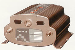
Each station determines its own transmission schedule (slot), based upon data link traffic history and knowledge of future actions by other stations. A position report from one AIS station fits into one of 2250 time slots established every 60 seconds. AIS stations continuously synchronize themselves to each other, to avoid overlap of slot transmissions. Slot selection by an AIS station is randomized within a defined interval, and tagged with a random timeout of between 0 and 8 frames. When a station changes its slot assignment, it pre-announces both the new location and the timeout for that location. In this way new stations, including those stations which suddenly come within radio range close to other vessels, will always be received by those vessels.
The required ship reporting capacity according to the IMO performance standard amounts to a minimum of 2000 time slots per minute, though the system provides 4500 time slots per minute. The SOTDMA broadcast mode allows the system to be overloaded by 400 to 500% through sharing of slots, and still provide nearly 100% throughput for ships closer than 8 to 10 NM to each other in a ship to ship mode. In the event of system overload, only targets further away will be subject to drop-out, in order to give preference to nearer targets that are a primary concern to ship operators. In practice, the capacity of the system is nearly unlimited, allowing for a great number of ships to be accommodated at the same time.
The system coverage range is similar to other VHF applications, essentially depending on the height of the antenna. Its propagation is slightly better than that of radar, due to the longer wavelength, so it�s possible to �see� around bends and behind islands if the land masses are not too high. A typical value to be expected at sea is nominally 20 nautical miles. With the help of repeater stations, the coverage for both ship and VTS stations can be improved considerably.
The system is backwards compatible with digital selective calling systems, allowing shore-based GMDSS systems to inexpensively establish AIS operating channels and identify and track AIS-equipped vessels, and is intended to fully replace existing DSC-based transponder systems.
A Class A AIS unit broadcasts the following information every 2 to 10 seconds while underway, and every 3 minutes while at anchor at a power level of 12.5 watts. The information broadcast includes:
MMSI number - unique referenceable identification
Navigation status (as defined by the COLREGS - not only are "at anchor" and "under way using engine" currently defined, but "not under command" is also currently defined)
Rate of turn - right or left, 0 to 720 degrees per minute (input from rate-of-turn indicator)
Speed over ground - 1/10 knot resolution from 0 to 102 knots
Position accuracy - differential GPS or other and an indication if (Receiver Autonomous Integrity Monitoring) RAIM processing is being used
Longitude - to 1/10000 minute and Latitude - to 1/10000 minute
Course over ground - relative to true north to 1/10th degree
True Heading - 0 to 359 degrees derived from gyro input
Time stamp - The universal time to nearest second that this information was generated
In addition, the Class A AIS unit broadcasts the following information every 6 minutes:
MMSI number - same unique identification used above, links the data above to described vessel
IMO number - unique referenceable identification (related to ship's construction)
Radio call sign - international call sign assigned to vessel, often used on voice radio
Name - Name of ship, 20 characters are provided
Type of ship/cargo - there is a table of possibilities that are available
Dimensions of ship - to nearest meter
Location on ship where reference point for position reports is located
Type of position fixing device - various options from differential GPS to undefined
Draught of ship - 1/10 meter to 25.5 meters [note "air-draught" is not provided]
Destination - 20 characters are provided
Estimated time of Arrival at destination - month, day, hour, and minute in UTC
Types of Automatic Identifications Systems
ITU-R Recommendation M.1371-1 describes the following types of AIS:
Class A
Shipborne mobile equipment intended for vessels meeting the requirements of IMO AIS carriage requirement, and is described above.
Class B
Shipborne mobile equipment provides facilities not necessarily in full accord with IMO AIS carriage requirements. IEC has begun work on a Class B certification standard, which should be completed by 2004 - 2005. The Class B is nearly identical to the Class A, except the Class B:
Has a reporting rate less than a Class A (e.g. every 30 sec. when under 14 knots, as opposed to every 10 sec. for Class A)
Does not transmit the vessel's IMO number or call sign
Does not transmit ETA or destination
Does not transmit navigational status
Is only required to receive, not transmit, text safety messages
Is only required to receive, not transmit, application identifiers (binary messages)
Does not transmit rate of turn information
Does not transmit maximum present static draught Class B devices are not yet available.
AIS Guidelines, Recommendations, and Standards
IMO Resolution MSC.74(69), Annex 3, RECOMMENDATION ON PERFORMANCE STANDARDS FOR AN UNIVERSAL SHIPBORNE AUTOMATIC IDENTIFICATION SYSTEMS (AIS). This standard defines the basic performance requirements for AIS equipment, and was used by International Telecommunications Union and International Electrotechnical Commission in developing technical and test standards.
IMO Resolution A.917(22), GUIDELINES FOR THE ONBOARD OPERATIONAL USE OF SHIPBORNE AUTOMATIC IDENTIFICATION SYSTEMS (AIS). These 14 page guidelines have been developed to promote the safe and effective use of shipborne Automatic Identification Systems (AIS), in particular to inform the mariner about the operational use, limits and potential uses of AIS. Consequently, AIS should be operated taking into account these Guidelines.
IMO Safety of Navigation Circular.227, GUIDELINES FOR THE INSTALLATION OF A SHIPBORNE AUTOMATIC IDENTIFICATION SYSTEM (AIS). These 14 page guidelines, prepared by the International Association of Lighthouse Authorities (IALA) and adopted by the International Maritime Organization (IMO), contains guidelines for manufacturers, installers, yards, suppliers and ship surveyors. It does not replace documentation supplied by the manufacturer. IMO SN Circ.245 amends these guidelines to recommend that AIS be connected through an uninterrupted power supply.
The International Maritime Organization (IMO), headquartered in London, is a specialized agency of the United Nations which is responsible for measures to inprove the safety and security of international shipping and to prevent marine pollution from ships. It also is involved in legal matters, including liability and compensation issues and the facilitation of international maritime traffic. It was established by means of a Convention adopted under the auspices of the United Nations in Geneva on 17-March 1948 and met for the first time in January 1959. It currently has 165 Member States.
IALA GUIDELINES ON THE AUTOMATIC IDENTIFICATION SYSTEM (AIS) VOLUME 1:
Part I - Operational Issues, Edition 1.3..
Part II - Technical Issues, Edition 1.1.
The International Association of Lighthouse Authorities (IALA) is a non profit making international technical association. Established in 1957, it gathers together marine aids to navigation authorities, manufacturers and consultants from all parts of the world and offers them the opportunity to compare their experiences and achievements. IALA is encouraging its members to work together in a common effort to harmonize aids to navigation worldwide and to ensure that the movements of vessels are safe, expeditious and cost effective and at the same time protect the environment.
ITU-R Recommendation M.1371-1, TECHNICAL CHARACTERISTICS FOR A UNIVERSAL SHIPBORNE AUTOMATIC IDENTIFICATION SYSTEM USING TIME DIVISION MULTIPLE ACCESS IN THE MARITIME MOBILE BAND. The International Telecommunications Union Sector for Radiocommunications formally adopted this standard in August 2001. This is the standard that defines in detail how the AIS works, and as such is the primary AIS standard. It can be purchased electronically from ITU. ITU gave IALA the responsibility of maintaining technical guidelines for AIS design, and is available from them as "IALA TECHNICAL CLARIFICATIONS ON RECOMMENDATION ITU-R M.1371-1".
The International Telecommunications Union (ITU), headquartered in Geneva, Switzerland is an international organization within the United Nations System where goverments and the private sector coordinate global telecom networks and services. The Union was established last century as an impartial, international organization within which governments and the private sector could work together to coordinate the operationof telecommunication networks and services and advance the development of communications technology. While the organization remains relatively unknown to the general public, ITU's work over more than one hundred years has helped create a global communications network which now integrates a huge range of technologies, yet remains one of the most reliable man-made systems ever developed.
IEC 61993-2 Ed.1, MARITIME NAVIGATION AND RADIOCOMMUNICATION REQUIREMENTS - AUTOMATIC IDENTIFICATION SYSTEMS (AIS) - PART 2: CLASS A SHIPBORNE EQUIPMENT OF THE UNIVERSAL AUTOMATIC IDENTIFICATION SYSTEM (AIS) - OPERATIONAL AND PERFORMANCE REQUIREMENTS, METHODS OF TEST AND REQUIRED TEST RESULTS. The International Electrotechnical Commission (IEC) formally adopted this standard in November 2001, and a published version is available from IEC. This standard defines the certification test requirements for Class A shipborne AIS equipment.
The IEC is the leading global organization that prepares and publishes international standards for all electrical, electronic and related technologies. These serve as a basis for national standardization and as references when drafting international tenders and contracts. Through its members, the IEC promotes international cooperation on all questions of electrotechnical standardization and related matters, such as the assessment of conformity to standards, in the fields of electricity, electronics and related technologies.